
If you’re an outdoors enthusiast, you may wonder how to download offline maps to your Apple Watch. Here’s how it’s done.
Maps

Moovit's New Live Location Feature Makes Urban Mobility Easier Than Ever
Urban mobility app Moovit has officially announced the new Live Locations feature, creating even more efficiency for those that commute.

Instagram Rolls Out New Mapping Features to Help Users Discover More Places
Instagram has added new mapping features to its social media app, allowing users to discover nearby places and see what users are sharing.

Updated Version of Apple Maps Arrives
Apple unveiled an overhauled version of Apple Maps with a number of new features aimed to improve the navigation app.

Detailed Look at Apple Maps in iOS 13
Check out this detailed look at Apple Maps in iOS 13 at MacStories. New features, a new look, and an aggressive move to make Apple Maps rival or beat Google Maps, make this a significant upgrade, and MacStories lay it all out.
Timed with the spread of its first-party mapping data, Apple is giving the Maps app a big upgrade in iOS 13 that represents the company’s biggest push yet to overtake Google Maps as the world’s most trusted, go-to mapping service. Apple Maps in iOS 13 represents – if you’re in the US at least – Apple’s purest vision to date for a modern mapping service. Here’s everything that it brings.

Waze Update Willl Show Toll Road Prices
An update for Waze rolling out today will show toll road prices along your driving route for users in the United States and Canada.

How to Use Maps on Your iPhone to See the Hourly Weather Forecast
You can use Apple’s Maps app on your iPhone to see the local hourly forecast without having to use the Weather app. Here’s how.

Apple Advertises for AR Jobs that May Involve Maps
Apple has six recent job postings for Augmented Reality (AR) positions, and they could be for a Maps-related project.
Apple Maps Revamp - TMO Daily Observations 2018-06-29
John Martellaro and Dave Hamilton join Jeff Gamet to share their thoughts on the major revamp coming to Apple Maps in iOS 12.

Apple Maps Suffering from Service Outage
Apple Maps suffered a temporary outage Friday morning, leaving many people wondering how to get where they needed to go.

iOS: Use Predictive Text to Share Your Location
Sharing your location with other people is the subject of today’s Quick Tip! While there are approximately a million ways to do so through iOS, you can actually use predictive text to pass along your location, so we’re going to tell you what magic words you’ll need to try it out.
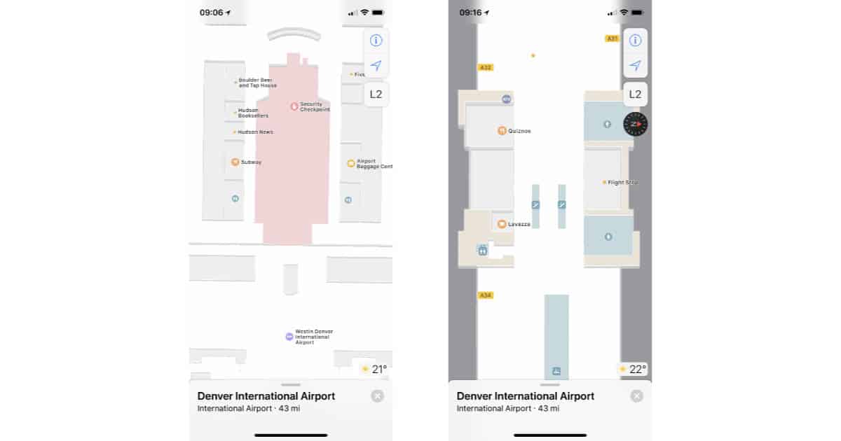
Apple Maps can Navigate You Inside Airports
Navigating airports is a little easier because Apple’s Maps app has been adding floor plans for many terminals as part of its indoor mapping project. Right now indoors maps are available for many U.S. airports, along with a few other cities such as London, Berlin, Hong Kong, and Toronto. The maps include restaurants and shops, directs to gates, and more. It’s all just there, so you don’t need to worry about any app updates before your next trip.

VR Apple Maps in iOS 11
Apple’s going big on augmented (AR) and virtual reality (VR) with iOS 11, and it appears those plans include the Apple Maps app. It was discovered this week that Maps locations which currently support “Flyover Tours” will now have a VR mode called just “Flyover” (minus the Tours). When accessed, the user sees the traditional Flyover view, but instead of the predefined tour video, the view responds to the user’s movement and the position of the iPhone. While currently providing a VR view, it appears that future plans call for AR too, as you’ll get a warning while using the app if there isn’t enough light for the camera. Check it out if you’re running the iOS 11 Beta.
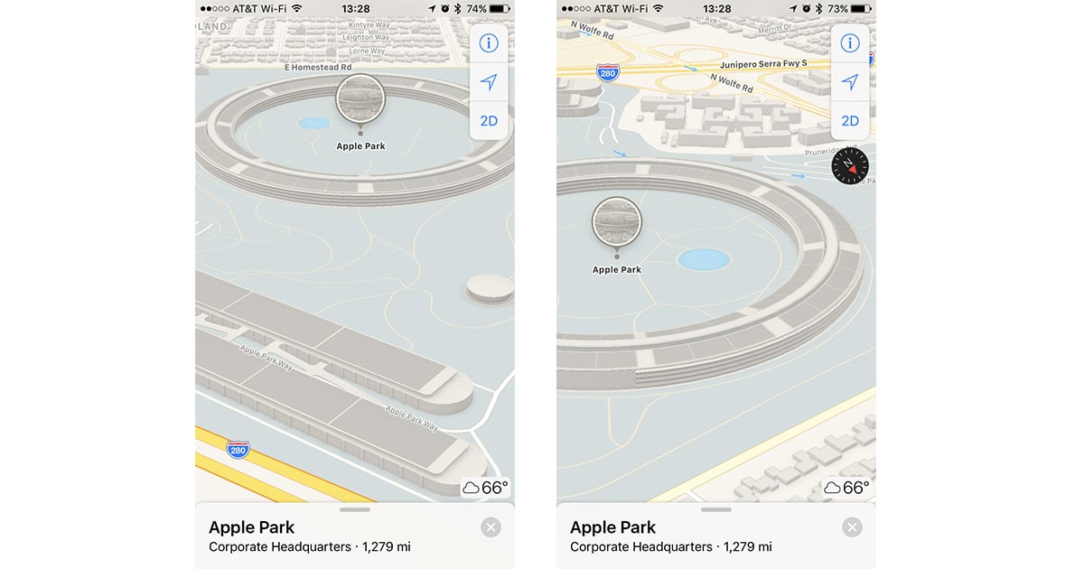
Apple Maps Adds 3D View for Apple Park Campus
Apple Maps is making it easier to pretend like you’re flying your own drone over Apple Park because now it offers a 3D view of the campus. Just search for “Apple Park” in Maps and do a two-finger swipe up to switch to 3D view. Now you can swipe and twist around to see the structures and landmarks, including the giant ring-shaped main building. It’s not quite the same as actually going there, but it’s still cool to see the campus from the perspective you want.

How Can I Share My Location From iOS Maps?
It’s easy to use “Share My Location” in Messages, but there are plenty of times when you might want to send a saved marker straight from Maps. Maybe you’re planning a family vacation and have found a cool point of interest to visit, or perhaps you want to scout out new coffee shops to visit with your friends. Jeff Butts walks you through saving a map location and then sharing it, step by step.

Apple to Unleash a Fleet of Flying Drones to Improve Maps Data
Apple Maps has come a long way, but still trails Google in many areas. Apple is therefore preparing a fleet of flying drones to take to the skies in an effort to greatly increase the volume and accuracy of the company’s mapping data.
iOS 10 Maps: Adding Pit Stops Along Your Route
Today’s Quick Tip is about how to use the redesigned Maps app to get directions along your route, so you can stop at a gas station or grab coffee when you’re already navigating somewhere. This feature will even help you figure out how much time making a pit stop will add to your trip, so come find out how to use it!